 Mijn Studiezaal (inloggen)
 85 kaarten
sorteren op:
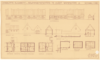
3A51
Bouwtekening van woningen van de Charlotte Elisabeth van Beuningenstichting, aan de Piekenhoek te Vught, 1937
Info
Klik op de afbeelding voor meer informatie
Organisatie

3A25
Matenplan uitbreidingsplan Zonneheuvel te Vught, 1981
Info
Klik op de afbeelding voor meer informatie
Organisatie

3A24
Situatieschets bebouwing Vught, hoek Boxtelseweg - Zandstraat, 1951
Info
Klik op de afbeelding voor meer informatie
Organisatie

3A23
Situatieschets grondeigendommen Parochie H. Hart, te Vught, 1932
Info
Klik op de afbeelding voor meer informatie
Organisatie

1C21
Plattegrond van geheel Vught: gebouwen, 1948
Info
Klik op de afbeelding voor meer informatie
Organisatie

1C20
Plattegrond van geheel Vught, met wijkindeling, 1948
Info
Klik op de afbeelding voor meer informatie
Organisatie

1C19
Plattegrond van Vught-noord, gemaakt i.v.m. volkstelling 1971, 1971
Info
Klik op de afbeelding voor meer informatie
Organisatie

1C18
Plattegrond Vught-centrum, gemaakt i.v.m. volkstelling 1971, 1971
Info
Klik op de afbeelding voor meer informatie
Organisatie

1C17
Plattegrond van Vught-zuid, gemaakt i.v.m. volkstelling 1971, 1971
Info
Klik op de afbeelding voor meer informatie
Organisatie

1C16
Plattegrond van geheel Vught, gemaakt i.v.m. volkstelling 1971, 1971
Info
Klik op de afbeelding voor meer informatie
Organisatie

1C15
Huisnummerkaart van Vught-noord, 1970
Info
Klik op de afbeelding voor meer informatie
Organisatie

1G08
Plattegrond van geheel Vught, inclusief Cromvoirt, 1950
Info
Klik op de afbeelding voor meer informatie
Organisatie