 Mijn Studiezaal (inloggen)
 85 kaarten
sorteren op:

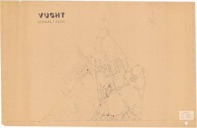
1C17
Plattegrond van Vught-zuid, gemaakt i.v.m. volkstelling 1971, 1971
Info
Klik op de afbeelding voor meer informatie
Organisatie

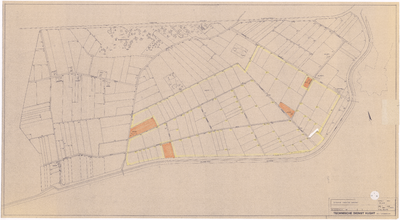
1C16
Plattegrond van geheel Vught, gemaakt i.v.m. volkstelling 1971, 1971
Info
Klik op de afbeelding voor meer informatie
Organisatie

1C15
Huisnummerkaart van Vught-noord, 1970
Info
Klik op de afbeelding voor meer informatie
Organisatie

1G08
Plattegrond van geheel Vught, inclusief Cromvoirt, 1950
Info
Klik op de afbeelding voor meer informatie
Organisatie

1C14
Huisnummerkaart van Vught-zuidoost, 1970
Info
Klik op de afbeelding voor meer informatie
Organisatie

1C13
Huisnummerkaart van Vught-centrum, 1970
Info
Klik op de afbeelding voor meer informatie
Organisatie

1C12
Huisnummerkaart van Vught-zuidwest, 1970
Info
Klik op de afbeelding voor meer informatie
Organisatie

1C11
Verkeersmaatregelenkaart, tevens huisnummerkaart van Vught-zuid, 1970
Info
Klik op de afbeelding voor meer informatie
Organisatie
1C10
Verkeersmaatregelenkaart, tevens huisnummerkaart van Vught-noord, 1970
Info
Klik op de afbeelding voor meer informatie
Organisatie

4B01
Topografische kaart van Vught en Cromvoirt, 1830-1990, 1832
Info
Klik op de afbeelding voor meer informatie
Organisatie
1G01
Plattegrond met kadastrale nummers Vughtse Gement, 1975
Info
Klik op de afbeelding voor meer informatie
Organisatie

3A08
Kadastrale kaart gemeente Vught, sectie B2 : Zonneheuvel, 1923
Info
Klik op de afbeelding voor meer informatie
Organisatie